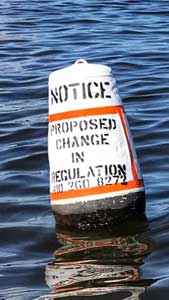
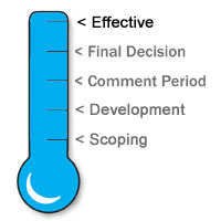
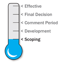
The information provided on this webpage is a summary of regulatory ideas and proposals that are being considered by the department. The purpose of posting this text is to make the public aware of the issues and to elicit public feedback on these ideas. Comments on the ideas presented provide the department with invaluable information and perspectives that may be incorporated into content or editorial changes. We appreciate your time and your commitment to Maryland's natural resources. The graphic within each topic will help you follow the change through the regulatory process.
If you wish to request a boating regulation change, please fill out one of the following forms:
Boating Regulation Change Requests are accepted annually through April 15. Requests submitted after the April 15 annual deadline will be considered the next calendar year.
If interested in more information on how to submit a Request for a Boating Regulation Change,
please call Mike Lathroum at 410-260-8272 or email:
kennethm.lathroum@maryland.gov
Click on a title below to be taken to a regulation change.
ANNE ARUNDEL COUNTY — Bodkin Back Creek
The department received a request to modify the current boating regulation in Bodkin Back Creek to 6 knots at all times during the year.
NOTE: After consideration, the department has decided to not move forward with this concept as a regulatory proposal
Top↑
ANNE ARUNDEL COUNTY — Bodkin Wharf Creek
The department received a request to modify the current boating regulation in Bodkin Wharf Creek to 6 knots at all times during the year.
NOTE: After consideration, the department has decided to not move forward with this concept as a regulatory proposal
Top↑
ANNE ARUNDEL COUNTY — Grays Creek
The department received a request to expand the current 6 knot speed regulation out to red day mark #2, then further extend the 6 knot restriction from the Grays Creek entrance to Long Cove Point and to the Little Island, then over to Hickory Point and back to the entrance of Grays Creek. This is a total length from the Grays Creek entrance to red day marker #2 of approximately 333 meters.
Top↑
ANNE ARUNDEL COUNTY — Stoney Creek
The department received a request to expand the current boating regulation in Stoney Creek to the mouth of the creek, and to have the expanded area be 6 knots at all times during the year.
NOTE: After consideration, the department has decided to not move forward with this concept as a regulatory proposal
Top↑
ANNE ARUNDEL COUNTY — Yantz Creek
The department received a request to expand the current regulated area of Yantz Creek approximately 400 feet down the waterway, south by southwest, towards the Severn River.
The speed limit in the current area is 6 knots at all times during the year.
Top↑
BALTIMORE COUNTY — Bear Creek, Lynch Cove
The department received a request to extend the 6 knots all times zone from the existing 6 knots all times area at the Bear Creek Bridges up Bear Creek to include Lynch Cove. This would be a modification of an area currently part of the Upper Bear Creek management area.
NOTE: After consideration, the department has decided to not move forward with this concept as a regulatory proposal
Top↑
BALTIMORE COUNTY — Frog Mortar Creek
The department needs to amend the speed limit in Frog Mortar Creek and Stansbury Creek. The limit will be changing from a speed limit of 6-knots on Saturdays, Sundays, and State holidays all year to a speed limit of 6-knots on Saturdays, Sundays, and State holidays during the boating season.
Top↑
BALTIMORE COUNTY — Middle River at Dark Head Creek
The department received a request to change the current boating regulation in Middle River in the area of Dark Head Creek. The affected area would be 6 knots at all times during the boating season.
NOTE: After consideration, the department has decided to not move forward with this concept as a regulatory proposal
Top↑
DEEP CREEK LAKE — Speed Limits and Restrictions
COMAR 08.18.33.03
The purpose of this action is to update and clarify existing boating laws and coordinates of certain boundaries.
There is an inlet between Beckman’s Peninsula and Harvey’s Peninsula that is very narrow so waterway users are restricted from towing in that area. The coordinates for the restricted area were incorrect. The proposed action describes the correct area.
The proposed action modifies the speed limit in the portion of the lake known as North Glade Cove. The cove is narrow with many obstacles and is heavily used by recreational vessels, both powered and non-powered. The proposed action defines the area with coordinates. The defined area is designated as a minimum wake zone.
Top↑
DORCHESTER COUNTY — Slaughter Creek and Chapel Cove
The department received a request to establish a regulated speed zone beginning at the mouth of Slaughter Creek and including the Chapel Cove waterway. The speed zone would be 6 knots all times during the year for the Slaughter Creek and Chapel Cove waterways.
Top↑
GENERAL — Personal Flotation Device Updates
The department needs to update its regulations regarding personal flotation devices (PFDs). The United States Coast Guard updated its PFD labeling requirements so that new PFDs are no longer identified by a type code The department’s regulations must recognize the possibility that a variety of United States Coast Guard approved PFDs may be onboard a vessel to meet requirements.
Top↑
HARFORD COUNTY — Susquehanna River at Havre de Grace
The department received a request to create a speed zone in Susquehanna River in the area of Havre de Grace. The affected area would be 6 knots at all times during the boating season. The requested area is approximately from the "Green 17" in the Susquehanna Channel extending north to the upstream side of the Susquehanna Lock House and Museum.
Top↑
Housekeeping — Report of Boating Accidents
The Department is considering updating the regulation for the report of boating accidents, specifically, the dollar amount which triggers the reporting requirement for an operator of a vessel involved in an accident. The department is also considering a minor housekeeping change in the same regulation regarding a grammatical error.
Top↑
KENT COUNTY — Swan Creek at Rock Hall
The department received a request to extend the speed zone in Swan Creek extending from Buoy marker #10 south to Gratitude Marina and modify the time period from Saturday, Sundays and holidays during the boating season to all times.
NOTE: After consideration, the department has decided to not move forward with this concept as a regulatory proposal
Top↑
MAGOTHY RIVER — Magothy River South Shore
COMAR 08.18.13.04
The purpose of this action is to expand the current demarcation line for the speed zone on Cool Springs Cove and Forked Creek. The proposed action relocates the demarcation line for the 6 knot speed limit that is in place at all times during the year approximately 400 feet north (downstream) of the current line. This will help account for large wakes being experienced by local residents and the marina due to newer styles of watercraft being used in this area over the last several years. The proposed action also reorganizes the section so that the regulation complies with formatting rules. This action will increase safety for all waterway users, community marinas, and privately owned waterfront properties within the waterway area.
Top↑
NAVIGATIONAL RULES — Housekeeping
COMAR 08.18.01.04
The purpose of this action is to update the regulation that requires boaters to follow the federal rules for operating in Maryland waters. During a review of the regulation it was discovered that certain information in the regulation was incorrect. The proposed action corrects the name of the federal act, cites the appropriate sections of the Code of Federal Regulations, and removes the reference to rules that are incorporated by reference. The document that is incorporated by reference is a guide about navigation rules that no longer exists. The guide has been updated and is available on the United States Coast Guard’s website. The Code of Federal Regulations, 33 CFR §83, requires an individual to carry the guide on the vessel. Therefore, it is no longer necessary to specifically reference the guide in regulation because it is included as part of the requirement to comply with the Inland Navigational Rules Act of 1980.
Top↑
QUEEN ANNE’S COUNTY — Queenstown Creek and Little Queenstown Creek
The department received a request to establish a regulated speed zone with a 6 knot speed limit at all times during the year in Queenstown Creek and Little Queenstown Creek.
Top↑
QUEEN ANNE’S COUNTY — Upper Corsica River
The department received a request to establish a new speed zone in the area from Centreville Landing (wharf) downstream to Sycamore Point. The request is for the speed limit in the area to be 6 knots at all times during the year.
Top↑
ST. MARY'S COUNTY — Jutland Creek
The department received a request to create a speed zone in Jutland Creek from immediately preceding the mouth of Jutland Creek off Smith’s creek to the entrance at Fox Harbor. The area would be 6 knots at all times.
NOTE: After consideration, the department has decided to not move forward with this concept as a regulatory proposal
Top↑
SOMERSET COUNTY — Jones Creek
The department received a request to create a new speed zone in Jones Creek located north of Janes Island in Somerset County, Maryland.
Top↑
SOUTH RIVER — South River Proper
COMAR 08.18.25.02
The purpose of this action is to change the speed limit in the area near the Riva Bridge to be consistent with the speed limit in the Route 2 bridge area. The proposed action changes the speed limit for the Riva Bridge area from 6 knots on Saturdays, Sundays, and holidays during the boating season to 6 knots at all times. The proposed action also reorganizes the section so that the regulation complies with formatting rules.
Top↑
STATEWIDE — Boat Act Advisory Committee
The department would like to update the regulations for the Maryland Boat Act Advisory Committee. The Maryland Boat Act Advisory Committee is one of several advisory bodies for the department. The regulation will be updated by correcting references to statute, removing duplicative wording, and making the requirements consistent with other advisory bodies.
Top↑
STATEWIDE — Validation Stickers
The department needs to clarify the regulation for validation stickers. Specifically:
- The reference to the statute is incorrect and will be updated;
- The regulation needs to specify that two stickers are required on the vessel;
- The regulation needs to specify that the stickers need to be placed within six inches of the vessel identification number; and
- There needs to be a process specified in regulation for a temporary sticker issued to an individual when they purchase a vessel from a licensed dealer.
Top↑
WASHINGTON COUNTY — Potomac River Upstream of Dam 4
The department received a request to create a new speed zone in the Potomac River approximately 10 miles above Dam 4. The area would have a 6 knots at all times during the boating season (April 15 – October 15) speed limit. Please note that initially, the department believed the request required an extension of the Dam Number 4 area. However, after further analysis no extension of the Dam Number 4 area is needed. The department has updated the maps to better identify the specific request and the comment period has been extended.
NOTE: After consideration, the department has decided to not move forward with this concept as a regulatory proposal
Top↑
WHITEHALL BAY — Mill Creek
COMAR 08.18.29.03
The purpose of this action is to expand the speed zone in Mill Creek. The department received a request to remove both the Mill Creek Proper (Northern Branch) and Martin Cove speed zone demarcation lines and establish a new demarcation line in the main stem of Mill Creek. The new line will begin just prior to the intersection of the waterways, approximately 235 yards down the main stem of Mill Creek waterway. The proposed action removes the descriptions for both the Martin Cove and Mill Creek Proper (Northern Branch) and establishes a new speed zone demarcation line for the combined and extended area. The proposed action establishes a 6 knot speed limit on Saturdays, Sundays and holidays all year for the entire area, which is the current rule for the Mill Creek proper and Martins Cove waterways.
Top↑
Regulation Definitions for Boating
Scoping
During the scoping process, the Department gathers suggestions and ideas from stakeholders and others about how to solve a boating problem or address a need. The goal of scoping is to identify issues, potential impacts, and reasonable alternatives associated with the issues so that management actions can be developed. The Department considers these comments and develops an appropriate management strategy.
Top↑
Development
After the public has had an opportunity to comment on the initial regulation request, the information is presented to the Boat Act Advisory Committee for further review. The public may make additional comments at the meeting. The Department, in consultation with the Boat Act Advisory Committee, considers the comments and develops an appropriate management strategy. The Secretary of Natural Resources then decides if a management strategy is necessary and appropriate. If the action is necessary and appropriate, a proposal is sent to the Joint Committee on Administrative, Executive and Legislative Review Committee (AELR). AELR analyzes each proposal for legal and fiscal concerns. The proposal is then sent to the Division of State Documents (DSD) for publishing in the Maryland Register. DSD staff edit the proposal for proper format prior to printing.
Top↑
Comment Period
This part of the process begins when the proposal is published in the Maryland Register. The public comment period is 30 days for all proposed regulations in Maryland as required by State law. The Department welcomes public comment on proposed regulations. Comments on the proposal provide the Department with additional information and perspectives that in some cases may be incorporated into editorial changes.
Top↑
Final Decision
At the end of the 30 day comment period the Secretary of Natural Resources decides whether to approve or disapprove the proposed measure. A final action will be sent to the Division of State Documents (DSD) for printing in the Maryland Register.
Top↑
Effective
A final action is published in the Maryland Register stating the date that the management action is effective.
Top↑
Resolution of Previous Regulation Requests
View the Archived Resolution of Regulation Requests
