Water Trails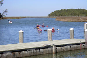
Named one North America’s best paddle trails by the American Canoe Association, Janes Island State Park offers more than 30 miles of marked water trails that meander throughout the island’s saltmarsh. Most of the waterways are protected from wind and current, providing ideal conditions for both experienced and novice paddlers. Three backcountry campsites are located along the trails for overnight expeditions.
 The Janes Island State Park Water Trail map/guide features seven water trails, all of which begin and end at the park's marina and boat launch. The trails provide a wide variety of paddling experiences so there are options for all levels of expertise. The map/guide also includes information on park amenities, camping, boating safety and regulations and the area’s natural resources. The trails range in length from 1.25 to 12.5 miles and include routes along the open waters of Tangier Sound, the Big and Little Annemessex Rivers as well as various creeks and marsh routes. This map/guide is available at Janes Island State Park and from the DNR Outdoor Store at http://shopdnr.com/watertrails.aspx. To view a pdf version of the water map,
  click here.
The paddle trails in and around Janes Island have been posted with aluminum signs. They are 12" x 18" and covered with a highly reflective film. Each trail now has not only a different color sign but a distinctive shape, as well, e.g.: red octagon with a white reflective slash, black diamond, yellow triangle, brown square, green circle and blue quadrilateral. All trailheads flow from the central Yellow Trail. Once on the trail, trail markers and colored posts will guide your way. On the red, blue, and black trails, colored posts also guide you between signs. If you paddle more than 2 minutes without seeing the next marker, you may have gone in the wrong direction and should backtrack to the previous sign.
The blue and black trails can become difficult, if not impossible, to navigate at low tide. Be sure to check the tide table before embarking on your trip.
GPS waypoints for the six paddle trails around and through Janes Island are available below.
You will need two things....
 Download waypoints for GPS (Zip File)
- EasyGPS program (http://www.easygps.com/)
- You need this (or a similar program) to upload the GPS file to your unit
- Then take home an electronic souvenir of your trip. Upload your GPS tracks and waypoints to www.gpsvisualizer.com. View a Google Earth map of your travels and email a copy to your friends. Show them where you caught the big fish, saw the bald eagle or swam on the secluded beach.
