In the Chesapeake Bay, relative sea level rise is impacting low-lying coastal lands at twice the global average rate. Over the past 100 years, Maryland has seen a foot of relative sea level rise. Rising waters have caused the disappearance of 13 Bay islands. This is due, in part, to local isostatic rebound or land subsidence from the last glaciation period and to sea level rise. Many of the islands lost played a role in Maryland’s maritime culture as year-round residences for our watermen communities. Like our island communities, many coastal communities in today’s landscape are being threatened by encroaching waters. In order to address these impacts, the Maryland Department of Natural Resources has been developing new land conservation strategies to address the impacts of climate change and increase the resilience of vulnerable coastal habitats.
State Conservation Targeting
Maryland's Green Print identifies important natural areas of the state, and defines those that are considered the “best of the best” as Targeted Ecological Areas (TEAs) important for conservation. DNR has recently updated GreenPrint, incorporating climate change considerations and new resource data. This update includes removal from the TEAs of areas that will be subject to sea-level rise inundation by 2050 to avoid spending limited funding in areas likely to be submerged.
These vulnerable coastal areas can however include important wetland habitat. Wetlands provide a natural buffer against the impacts of coastal hazards such as sea-level rise and storm surge. They also provide ecological functions such as carbon sequestration, water filtration, critical wildlife habitat, as well as recreation. DNR utilized predictive models to determine priority “Wetland Adaptation Areas,” or corridors where wetlands will migrate inland as sea level rises. For more technical information on Wetland Adaptation Areas and SLAMM, see the report, “ Coastal Land Conservation in Maryland - Targeting Tools and Techniques for Sea Level Rise Adaptation and Response (November 2012)”. A sample of the full (low, medium and high) priority Wetland Adaptation Areas can be visualized on Maryland’s Coastal Atlas. See Figure 1 below.
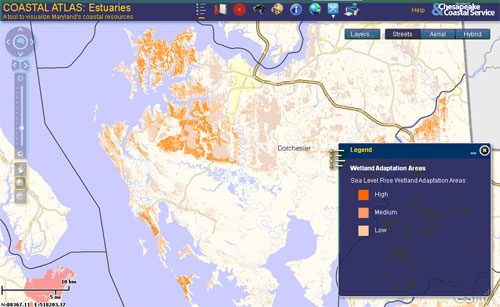
Figure 1: Dorchester County as seen in the screen capture from
the Coastal Atlas. Many of the coastal extents exclude extremely
low-lying
vulnerable areas
that were projected to be open water or
tidal flats by the year 2100. The high priority Wetland Adaptation Areas
include a range from high to low.
The implementation of this data into the TEAs will enable the GreenPrint targeting tool to incorporate climate change considerations that will influence how Maryland’s Program Open Space, Coastal Estuarine and Land Conservation Program (CELCP), Maryland Environmental Trust and other state and local land conservation programs prioritize and target lands in the coastal zone.
State Land Acquisitions
In accordance with DNR’s Building Resilience to Climate Change Policy, all potential land acquisitions through Program Open Space are reviewed for climate change impacts including sea-level rise, storm surge, shoreline erosion and wetland migration.
Properties considered through Program Open Space’s Community Connections Protocol will also be reviewed for climate change adaptation and mitigation opportunities. These properties may provide a public benefit such as storm surge protection to a community, carbon sequestration and urban tree canopy, or replacement of public access lost to sea-level rise.
Coastal Resilience Easements
DNR is also now incorporating climate change considerations into purchased Coastal Resilience Conservation Easements. Conservation easement provisions on properties located in the coastal zone may include development setbacks in areas subject to sea-level rise inundation by 2050, buffers to support high priority Wetland Adaptation Areas, impervious surface limits to reduce runoff and pollution due to increased storm events, and review of shoreline stabilization projects. Landowners may also request development of a Coastal Resilience Plan offering recommendations on land management practices to reduce vulnerability of their property to coastal hazards and improve the resilience of coastal habitats. The Coastal Resilience Plan may address wetland restoration, creation of living shorelines, invasive species management, environmental hazard management, and documentation of historic and cultural resources.

